

Mt Mitake and Mt Hinode are in Chichibu-Tama-Kai National Park, about 50Km west of Tokyo. It take around 2hrs to reach them from Shinjiku, on the Chuo and Ome lines to Mitake Station. I arrived at Mitake station at 2:30pm. Given the short December days, I had just about enough time to summit to Mitakesan and find my hotel before the light gave up. A cable car also runs up to Mitakesan. This Mt Mitake and Mt Hinode hike was over 15 miles long and involved over 4,000 ft of ascent. Parts of the hike were hard and steep.
Day 1 – To Mitakesan
 From Mitake Station, cross over the Tama river and head East. Next, pass a large hydro electric pipe and follow the road until there is a gap in the fence which protects the road from rock fall. At this point, an almost 45 degree ascent along a ridge starts. The fence appears to be relatively new and seems to block the original trailhead. At the gap in the fence, the new start seems only occasionally climbed but after a short steep ascent of about 200 meters, it joins something a little more recognizable as a trail. Occasional white tree markers and red topped posts mark the way, however, multiple random trees have the same white bands. Hiking poles are definitely required as the trail ascends 2,000ft in the first 2 miles. There are no signposts to the top, however, following the ridge is the option. To the left and right are steep but not dangerous drop offs. I was unlucky with the weather and visibility masked any views which may have been available. Thin pine trees, fog and an endless ascent were all that was on offer during my slow climb.
At the top a few signs (mostly in Japanese only) appear and a small town with a maze of tiny one-way roads.
Day 1 – Hotel
 I stayed at Nobori Hotel and would throughly recommend it. The map location on Booking.com is inaccurate, either use the GPS coordinates below or reenter the address into google maps to find it. Traditional Japanese food and lodging from extremely nice and friendly people. Nobori is full board and both dinner and breakfast was beautifully presented. The traditional feel added so much to the experience. Not all dishes were to my western tastes, however, the quantity allowed me to get plenty of energy from the dishes I liked and also try a variety of other foods. Being December, the night was cold but my traditional Japanese tatami matted room had a heater and the bedding was sufficient to keep me warm.
Day 2 – Nanayono falls
 In the morning, it was time to hit the trail. I imagine on clear days, the short hike up to the monastery rewards great views. For me, the fog was all I could see. From here, google maps were pretty useless, trails were no where near where they appeared to be. From Mt. Mitake, the Motion-X App maps were significantly better. Although my downloaded maps were far from perfect and most of the signs were only in Japanese, for the most part, a compass bearing was enough to keep me on track. From the monastery the path is fairly flat and well groomed. Take this path, heading south west for 1.5 miles, passing Ayahiro falls. The last half mile is steeper. Towards the top, turn east for half a mile. At the sign post, head north east towards the Rock Garden. This section is a steep descent. Chains and even a ladder helps the down climb, however, the positioning of the chains is pretty haphazard. Signs to Nanayono falls appear and these are reached after climbing down ten metal staircases.
Day 2 – Mt. Hinode
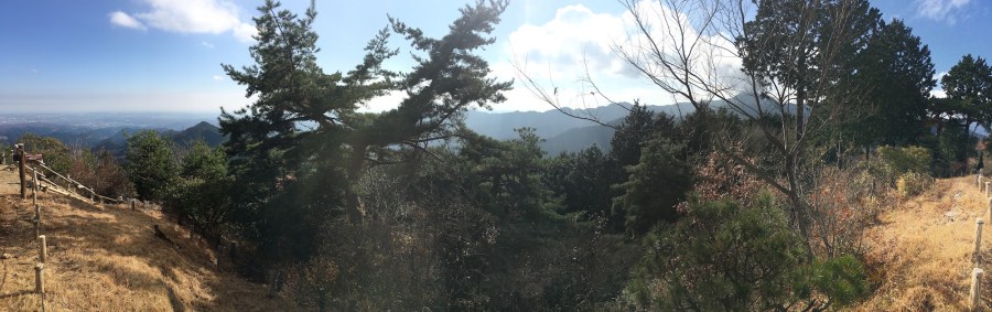
 Shortly after heading south east from the falls, a rough road is reached. The road follows a river down for 1.5 miles, with the exception of a single parked car, there was no signs of any vehicles. At a road junction turn left and start the climb up towards Mt. Hinode. The climb is roughly 1,500 ft in 2 miles. Finally, the clouds started to dissipate, however, the density of the forest made for very few views. Around the falls there were several other hikers but apart from that there was 20mins or so between them. Upon reaching Hinode summit, a through of folks were cooking up and chit chatting. The views were good and lunch was welcomed.
Day 2 – Descent
The way down is largely gentle on the knees – 2,500 ft in 5 miles. The views opened up and so long as I kept heading east-north-east, I’d hit the town. About 2 miles from Mt. Hinode summit, the descent became steeper and the trail was dotted with small shrines. The Mt Mitake and Mt Hinode route was not great for wide open views but thick forest made for a very peaceful hike.

Map data

Gear List – Mt Mitake and Mt Hinode
PACK
- Osprey Talon 28 – 800g
SLEEP / SHELTER
- None – Day hike
COOK SYSTEM
- Esbit UltraLight 11.5g
- Snow Peak 450 mug and lid 120g
- Survival matches. Survival basics ~ 10g.
- 2x solid fuel tablets. Survival basics ~20g.
- Docooler windshield
HYDRATION SYSTEM
- 2x 1.0L HydraPak bottles 215g
- Katadyn BeFree filter. Lots of ascent=lots of water. Bottled water would be fine but this trail has plenty of creeks, why carry it the whole way? 50g
OTHER KIT (IN DITTY BAG)
- InReach Satellite communicator. Mostly for this blog. ~200g
- 2x Wetfire tinder. Survival basics ~10g.
- Ben’s 30 tick & insect repellent. Reports of bugs. ~ 50g
- Black Diamond ION head torch. Survival basics – 55g
- REI small towel. For cooling down with a wet towel – 25g.
- Sea to Summit mosquito head net. Reports of bugs – 37g.
- Tyvek sit mat. Great for avoiding a wet backside during breaks ~ 10g.
- USB charger and cables. For my phone. ~ 150g
- Knife – none (aircraft carry-on luggage)
- First Aid – none (day-hike, close to services)
Total dry pack weight ~1.8Kg
(+ ~1Kg for spare clothing -waterproof+down jacket)
(+ ~0.5Kg food)
(+ ~1Kg water)
Total carried weight ~4.3Kg
KIT – WEAR/CARRY
- Suunto Clipper compass. Survival basics – 5g.
- Black Diamond Z-pole. Lots of ascent, no need to adjust length. ~350g
- OR Active Ice sun gloves. Habit – 20g
- OR Sparkplug gaiters. Keep any debris out of low-cut shoes -25g
- OR Sun runners hat. Sun forecast -79g
- Buff. Essential gear / habit.
- Camera phone
CLOTHING
-
- Arc’Teryx Beta SL waterproof – 680g.
- Arc’Teryx Motus crew T-shirt. Fabulous base layer.
- Arc’Teryx Atom LT vest
- Uniqlo down jacket. – 200g
- REI undershirt, fast wicking.
- Merrell SelectPerformix top
- REI boxer briefs
- Kuhl Kontra trousers. My favorite – always.
- Smartwool socks. Comfort padding.
- DryMax sock liners. Avoid blisters.
- Altra Lone Peak 3.5 trail running shoes. Light, cushioned with good grip.
CONSUMABLES
- Jerky
- Trail mix
- Boiled sweets
- GU energy gels
- Water ~1Kg


