

The post describes how to plan the TRT through hike. The TRT is a loop trail, it can be started at pretty much any point or trailhead and tackled in either direction. Since parking and leaving a car for almost two weeks seemed difficult, we elected to fly into Reno and then take an Uber to the trailhead at Tahoe Meadows. It was a quick and low cost flight for us on SouthWest from Oakland to Reno – just 1hour.Staying the night before meant that we could hit the trail late morning relaxed and prepared.With our starting point decided, planning the route was primarily decided based on a few key factors.
- Our pace
- Resupply & hotel stop-overs
- Water availability
Our pace
Walking without a pack over flat terrain at sea level, most reasonablly fit people will be comfortable walking at around 3 to 3.5mph. Add a 20-30lb pack, add 2,000ft of ascent per day and move up to 8,000ft from sea level and the comfortable sustained pace over multiple days is going to drop – significantly. To be clear, we were planning for this to be an enjoyable experiance and have time to enjoy the sights – no sadism required. I figured that if we walked at a sustained average of 2mph (including breaks), an average of 13 miles per day would mean 3 hours hiking in the morning (9-noon) and 3.5 in the afternoon (1:00-4:30pm). Plenty of time to accommodate longer days, resupply, mishaps, detours, dips in the lake and relaxation time. We’d need 13 days.
Resupply & hotel stop-overs
Now we had a start point and average pace, next, I needed to map this over the trail and see how this mapped to potential resupply points – we had no intention to carry 13days of food. About 1/4 of the way around from our starting point, the trail goes though Kingsbury. I found an AirBnB place not far off the trail. The TRT drops down into Tahoe City, so that was an obvious resupply point about 3/4 of the way around. Echo chalet is around 1/2 way around. I read they once – but no longer – accept resupply packages – shame. The nearest USPS from Echo is Meyers around 4.5miles away. According to AT&T coverage map, I would have cellular reception in Nebelhorn to call a car. //a mistake here! although my local USPS happily shipped my package, it turned out that Meyers USPS only holds PO Box packages. We had to collect it in South Lake Tahoe – 12miles from the trail//. Three resupply points meant we’d have to carry 3-4days of food.
Water availability
Water is heavy and there are some pretty long sections where it is not available or only seasonally available. Although this hike is around a lake, except for when the trail drops down to Tahoe City, it’s a long long way away. Most of the hike is at or around the top of the mountain and water is a stuburn slave to gravity…. Desolation wilderness has plenty of granite water capturing lakes. The TRT Association site has excellent information on year around water sources. Given the timing of our through hike, we had very good chances of being able to use seasonal ones too.As described in the planning tools page, AllTrails is a fantastic app for planning hikes in the regions they cover. It took several trial and error attempts, however, I finally settled on the route below. (links to GPX files at the bottom of this page)
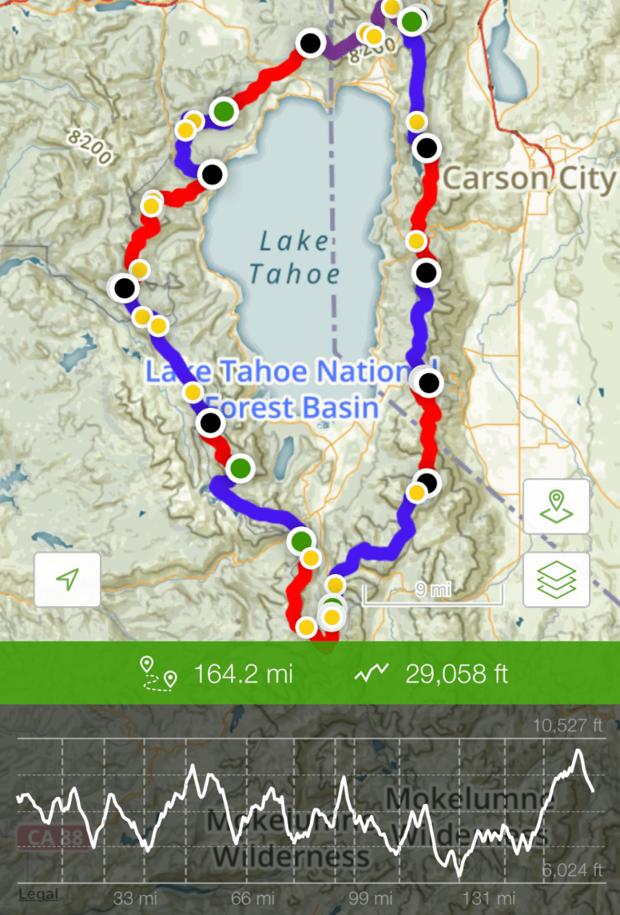
As a consumate geek, I also attempted to estimate our day by day speed, largly to get a feel for what time we’d need to hit the trail each day in order to arrive at a reasonable time. Our ‘Ascent Factor’ is an attempt to normalize our ascent to 1.0. I choose 1,800ft. to be our normalization point and used the equation (ActualAscent+1200)/3000 to give a range I was happy with – 80% to 140%. Now I could use this factor to adjust each day’s speed faster or slower to account for the amount of ascent. With this adjusted speed, I could then estimate what time we’d need to leave in order to arrive at 5-6pm.
